Figures from 1998 Report for COSEWIC: Status of Atlantic Cod in Canada
Legends appear below each figure.
Figures from 1998 Report for COSEWIC: Status of Atlantic Cod in Canada
Legends appear below each figure.
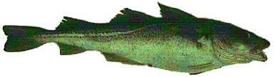
Figure 1. Gadus morhua. From photograph courtesy of DFO.
[range map: not included, see any Canadian NAFO areas chart]
Figure 2 [not included here, separate file required] . The western north Atlantic. Approximate range of Gadus morhua in stippling; actual incidence may vary. NAFO divisions are labelled on the map; the 200 nm current Canadian EEZ is shown by a dash-dot line; and the 500m depth contour is shown by a thin solid line. The "nose" of the Grand Bank is the easternmost portion, and the "tail" is the southeast portion; both lie outside the current EEZ, as does the Flemish Cap.
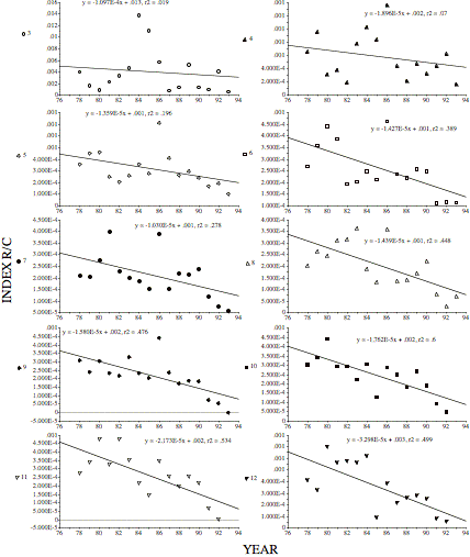
Figure 4. Decline in the 2J3KL index R/C for age 3-12 cod for over time. R/C is the ratio of the Research survey index divided by the Commercial catch index, here calculated from data reported in Myers and Cadigan (Myers & Cadigan 1995); R/C shows the relative behaviour of commercial and research survey catches. Age classes identified by Y axis label; the Y axis is the ratio R/C. Declining R/C shows that fish were becoming either more available to, or more targeted by, the commercial fleet relative to the research surveys. Trends in R/C are negative for all age groups over the time shown. Note that the presence of any meaning in these relationships has been challenged.
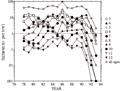
Figure 5. Research vessel average catches for 2J3KL, plotted from data in Myers and Cadigan (Myers & Cadigan 1995) show a drastic decline after 1990 for all year-classes.
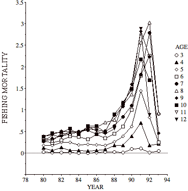
Figure 6. Fishing mortalities in 2J3KL. Fishing mortality (F) from the SPA model using standard assumptions, from Table 1 in Myers and Cadigan (Myers & Cadigan 1994).
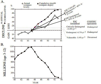
Figure 7. Recent changes in 2J3KL. A: Annual and cumulative (since 1984) rate of population loss for ages 3-12 in NAFO Divs. 2J3KL. B: millions of fish aged 3-12. A and B estimated from the cohort analysis table constructed using dependent lognormal errors for size of 2J3KL stock (Myers & Cadigan 1994); The dependent lognormal model appears to be a better fit to the data, as judged by residuals.
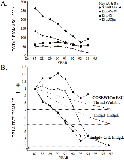
Figure 8. Summary data for declines of stocks in management areas: 4T, 4VsW, 4X, and 5Zjm. Data from Report DFO 94/4. A. Biomass changes in four management areas. B. Relative change. Biomass data from the report include only the four management areas shown (report does not give biomass data for areas 2GH, 2J3KL, 3Ps, 3Pn4Rs, 4Vn or 3NO). For the southern Gulf (4T) DFO includes catches in 4Vn:nov-apr and 4Vs:jan-apr which may have been associated with the southern Gulf stock. ESC guidelines expressed as rate of change are shown with labels.
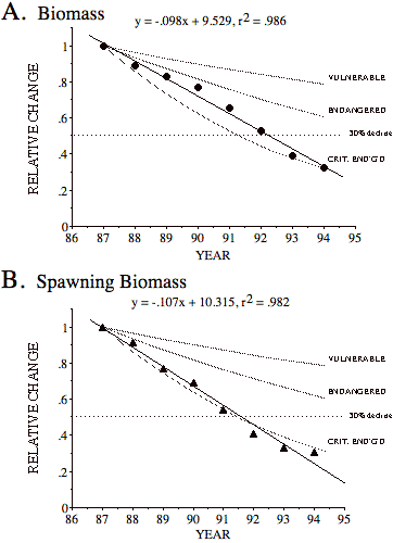
Figure 9. Recent trend in relative biomass (A) and relative spawning biomass (B) for 4 management areas together: 4T, 4VsW, 4X and 5Zjm. Source of data is DFO Stocks Status Report 94/4. Biomasses for each year summed, standardised relative to 1987 total. Biomass data from the report include only the four management areas shown (report does not give biomass data for areas 2GH, 2J3KL, 3Ps, 3Pn4Rs, 4Vn or 3NO). For the southern Gulf (4T) DFO includes catches in 4Vn:nov-apr and 4Vs:jan-apr which may have been associated with the southern Gulf stock. IUCN guidelines expressed as rate of change are shown with labels. Regressions are given above each graph.