 Back to Week 10 Notes.
Vignette: Distribution and utilization of Scots Bay chalcedony© 2001 Michael Deal
The following report concerns the prehistoric exploitation of lithic resources in the Scots Bay-Blomidon area of Nova Scotia.
The discussion focuses on the nature and distribution of lithic source locations within this area, and the aboriginal procurement
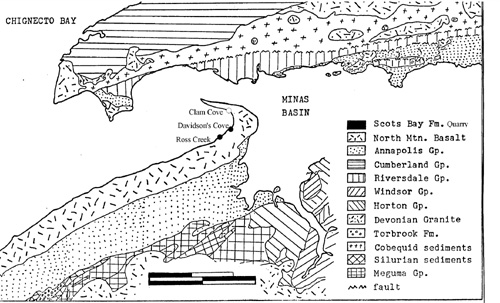
and processing of workable materials at a workshop site, at Davidson Cove, Scots Bay (Figure 1). Observations are also
made concerning the known regional distribution of the processed lithic materials.
The Scots Bay Formation
The lithic resources of Scots Bay and the Blomidon peninsula fall within the general class of sedimentary microcrystalline
silicates commonly called chert. In both the geological and archaeological literature, the term chalcedony is more often applied
to these deposits. Chalcedony is one of several subvarieties of chert distinguished on the basis of color, texture, internal
structure and water content. According to geologist, John Thompson (1974:151-152), the Scots Bay chalcedony is
characterized by a structure of well defined polyhedral blocks, few or no water-filled cavities, and as colorless or light brown in
transmitted light.
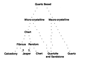
The relationships between common siliceous materials based on their crystal size and arrangement are illustrated in Figure 2
Hammer (1976:42). In archaeological terminology, chalcedony includes the fibrous subvarieties of cryptocrystalline quartz,
while chert, as a subvariety of cryptocrystalline quartz, is granular in nature (e.g., Crabtree 1967:12; Crotts 1985:48; Hammer
1976:40-41). In practice, the light color and waxy luster of chalcedony are important for archaeological identification. The
Scots Bay lithics also include the variegated subvariety of chalcedony, known as agate, and the more difficult to categorize
subvariety, jasper. Crabtree (1967:12) considers jasper an impure form of chalcedony that derives its distinctive red or yellow
color from inclusions of iron-based clay (1967:12). Ross Creek (Figure 1) is the source of a distinctive dark brown jasper.
Decades of geological research have established that the depositional environment for the Scots Bay limestones, which were
subsequently replaced by chalcedonies, was a shallow, freshwater lake that is also associated with the chalcedony rich deposits
of Cape D'Or and the jasper producing deposits on Isle Haute (Crosby 1962; Klein 1962; Thompson 1974:Chapter 9).
Throughout this area, the chalcedonies occur either as replacement nodules in limestone or siltstone, or as extensive bedded
deposits in limestone (Thompson 1974:144). According to Thompson, the nodules are typically red, reddish-brown, and
brown due to disseminated hematite, and they are generally cylindrical in shape, with their axes laying parallel to the
paleocurrent direction (1974:144). The nodules in limestone can be up to 30 cm in diameter and two meters in length.
Chalcedony beds in limestone are generally less than five centimeters thick and predominantly blue-gray in color (Thompson
1974:152). Geochemical analysis by Thompson (1974:154), indicated chemical differences between the nodules and beds,
with the nodules being higher in silica and lower in all other targeted elements.
Several locations of chalcedony beds were recorded in 1964 by geologists from the Nova Scotia Museum (N. S. M. 1965), in
conjunction with archaeological work at the Debert Paleoindian site. Except for two areas with abundant chalcedony veins,
these beds are generally thin and isolated. Nodules of chalcedony are also scattered on the beaches of most of the large coves.
The coves nearer to the point are difficult to reach on foot due to high cliff faces, sometimes over 60 meters above the
shoreline. Of the four archaeological sites identified, only the shellmidden site at Clam Cove, (BhDc-5) has evidence of
extended occupation.
The source area along Scots Bay forms part of what Thompson calls the Scots Bay Formation. It has several major outcrops
of chalcedony. Two of these are easily reached on foot, while access to the other outcrops is limited by tidal activity. Water
worn nodules of chalcedony are easily gathered along the entire shoreline of this area and exposed chalcedony beds are
common. However, the only aboriginal workshop site known in the area, is associated with the outcrops at Davidson Cove.
Davidson Cove workshop
Quarrying and workshop areas are often neglected by archaeologists due to the vast quantities, and lack of variety in the
materials collected (Ericson 1984). However, they can be viewed as the initial stages of a tightly integrated system that involves
the selection, modification, distribution and consumption of lithic materials (Ericson 1984). They can provide valuable
information on quarrying procedures, tools and strategies for initial lithic reduction, and a wealth of analyzable debitage (Bryan
1950; Ericson 1984; Purdy 1971, 1984; Ritchie and Gould 1985; also see Hester and Heizer 1973). One pioneer in lithic
quarry studies estimated that nine-tenths of the initial reduction materials were left as wastage (Holmes 1919:178), and modern
experimental studies tend to support this assertion (e.g., Newcomer 1971). More recent studies have focused on tracing lithics
from various sites to their source locations for economic analysis (e.g., Gramly 1980).
The extensive workshop area at Davidson Cove lies on the eastern bank of Thorpe Brook, where it flows into Scots
Bay (Figure 1). Davidson Cove has been known to geologists for decades for its chalcedony outcrops, but the workshop area
was not officially recorded as an archaeological site until July of 1988 (Deal 1988). At that time, the site was mapped and
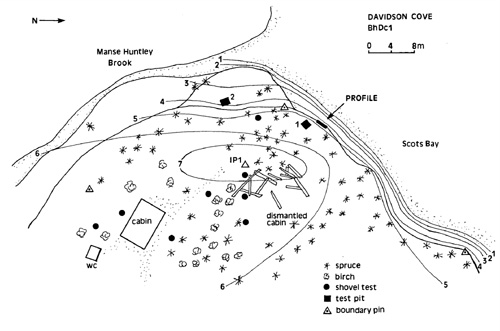
tested, and column samples were collected from a profile along the shore face (Figure 3).
The workshop site extends up the Manse Huntley Brook for at least 25 meters and along the shore face parallel to the Bay for
about 40 meters. It is situated on a ridge about six meters above the basalt shore, and well above the highest high tide level.
Erosion witnessed along the shore face is primarily due to winter storms and freeze-thaw activity rather than to tidal action. A
20 square centimeter column sample was taken from a profile along this shore face to provide an estimate of production
intensity at the site. A thick layer of debitage was recorded at the base of the initial humus layer, and the upper portion of the
underlying layer of silt (see Figure 4). The ratio of soil to lithics by weight for each of these layers was .81, while the ratio of soil
to lithics by volume for each layer was also identical at 2.4. In addition, 15.9 kilograms of flakes, core fragments and quarry
blanks were collected from a single one meter square test unit. The debitage was primarily chalcedony, with a wide range of
color variation.
While it is likely that both bedded chalcedony and nodules were used for making quarry blanks, decades of visitations by
geologists and rockhounds have resulted in the defacement of the bedded deposits by metal picks. While the debitage has not
yet been analyzed, the presence of three small quartzite hammerstones and one hammerstone/anvil indicates that initial reduction
was done using a hard hammer technique. The 20 quarry blanks collected were bifaces with very generalized morphologies,
and most of them seem to have been discarded because they could not be reduced to the desired thinness (for discussion see
Muto 1971). This assumption is based on the relatively large nodes of material left in the midsections of most specimens.
Regional Distribution
Earlier researchers, like John Erskine, had suggested that the cryptocrystalline lithics from the Bay of Fundy coastline were not
widely used until after 1200 A. D. (Erskine n.d.:86; also Sanger 1991). Two lines of evidence from Davidson Cove suggest a
Middle to Late Woodland period utilization of the Scots Bay chalcedonies. The first is a carbon-14 date of 1540 +/- 110 B. P.
(Beta 29379), derived from a charcoal lens on the interface of the two upper layers of the shore face profile (Deal 1988:7).
The lens was completely encased in debitage and is therefore believed to date to a time when the workshop was in operation.
The second piece of evidence is a small side-notched, Late Woodland projectile point from test unit one, which is the only
finished tool recovered from the site. Further, all other diagnostic artifacts thus far recovered from the Scots Bay area can also
be safely dated to the Middle or Late Woodland period.
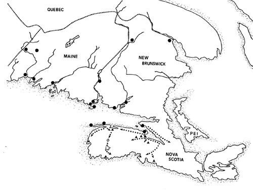
The map in Figure 5 illustrates the general distribution of chalcedony source areas throughout the Maine-Maritime Region, and
possible distribution networks within western Nova Scotia. The chalcedony sources, including outcrops and glacial till, are
based on rock and mineral guides for the region (Morrill and Hinchley 1959, 1981; Sabina 1965; also Gaunce 1984), and do
not necessarily represent sources exploited in prehistoric times. In fact, the only other identified aboriginal chalcedony
workshop in the Maritimes is on Washademoak Lake on the St. John River Drainage (Black and Wilson 1999; Crotts
1985:51; Gesner 1839:60; Matthew 1900:62-63). However, the widespread distribution of chalcedonies in Maine and New
Brunswick does tend to support a recent claim by David Sanger (1987:78), that the common belief that Scots Bay lithics were
being used the prehistoric inhabitants of Passamaquoddy Bay is probably unfounded. It seems likely that other workshop sites
will eventually be discovered along the southern coasts of New Brunswick and Maine.
In Nova Scotia, chalcedonies are only found along the Bay of Fundy shore from Digby Neck to Blomidon, and at Cape D'Or.
The black triangles on the map indicate archaeological sites in western Nova Scotia where chalcedonies from Fundy shore
sources have been identified (after Erskine 1960, 1986; Deal 1988; Deal et al. 1986; Nash et al. 1991; Sanger and Davis
1991; Sheldon 1986). It is significant that Fundy shore chalcedony is rarely encountered east of the Shubenacadie River (e.g.,
Nash 1986:29, 39), while chalcedonies from the Cape D'Or/Parsborro area have been identified at the Paleoindian site at
Debert (MacDonald 1968) and eastwards into Pictou County.
The arrows on the map (Figure 5) indicate the most likely distribution routes for Fundy shore chalcedonies. The triangles
represent sites in which lithic materials have been identified as made from Scots Bay chalcedony. The Scots Bay sources are
most easily accessed by water from the Minas Basin area, and the most abundant use of these chalcedonies is along the Minas
Basin and up the Gaspereau River to the Gaspereau Lakes. The southward distribution of Fundy shore chalcedony seems to
follow well known historic portage routes to the Atlantic, namely, via the Shubenacadie and Musquodoboit rivers in central
Nova Scotia and via the Laquille and Mersey rivers in southwestern Nova Scotia (see Deal et al. 1987). The source areas on
Digby Neck have not yet been surveyed by archaeologists. They may have provided the chalcedonies for inhabitants of the
southwestern coast and may also have moved along the Laquille-Mersey route via Bear River.
The areal distribution of this high quality lithic material within western Nova Scotia may be a reflection of late prehistoric
sociopolitical organization in the region. In particular, it corresponds closely to one of the seven Micmac political districts
known from the ethnohistoric literature. The western district, known as "kespoogwit," stretched from Cape Sable, at the
southwestern tip of the province to the Shubenacadie and Musquodoboit rivers (see Anderson 1919:45; Biard 1959:89; Speck
1922:93-105).
Since stone tools were largely replaced by iron ones during the Protohistoric period (Bailey 1969), we have no clear record of
the possible sociopolitical role of lithics within the region. Ethnographic data from other areas suggest that quarry sources are
generally held in common among groups of hunter-gatherers. However, the production of generalized quarry blanks at
Davidson Cove seems to indicate that the workshop knapper did not know the consumer and may therefore suggest the use of
lithics in some form of intraregional exchange (see Ericson 1984:6). If consumption was local, workshops might be expected to
produce a wider variety of finished tools to reduce transport loads (see Ericson 1984; Gramly 1980). However, it is also
possible that fewer finished tools were produced to reduce the amount of time spend at workshop sites.
If Scots Bay chalcedonies were being used in a lithic exchange system, it is likely that access was restricted at the local band
level. While the ethnohistoric literature hints at a complex political hierarchy of chiefs and councils (Miller 1983), this structure is
probably a product of contact with Europeans, as well as the Eurocentric views of the early chroniclers. The lowest level of this
hierarchy is probably our most useful model for the precontact era. It consists of a local leader responsible for a group of
related families who shared a specific summer camp. In historic times, each of these family bands controlled specific hunting
territories around lakes and river courses (Speck 1922). Summer meetings were important for arranging marriages, settling
disputes, and cooperate economic projects.
In the precontact era, this would also be the ideal time for excursions to the quarry sites on the Fundy shore. Quarry blanks and
some finished tools produced at Scots Bay were probably taken to summer camping areas, like Melanson, on the Gaspereau
River. If the quarry blanks were made intentionally for exchange with other local bands within the district, this exchange was
most likely on a small scale. This may have involved infrequent exchanges between family bands along the borders of hunting
territories or at contact points along major portage routes.
While this discussion of the distribution of Scots Bay chalcedonies is largely speculation, it does seem to correspond with the
available archaeological and ethnohistorical information. In future, trace element analysis of lithics from quarrying locations and
tools from various sites may help to define these lithic distribution patterns more clearly (e.g., see Dincauze 1976; Luedtke
1978, 1979). However, we can say that Scots Bay chalcedony was a valuable and widely distributed commodity during the
Middle and Late Woodland period in western Nova Scotia.
References
Anderson, W. P. (compiler)
1919 Micmac place-names in the Maritime Provinces and Gaspe Peninsula, recorded by S. T. Rand. Surveyor General's
Office, Ottawa.
Bailey, A. G.
1969 The conflict of European and eastern Algonkian cultures 1504-1700. University of Toronto Press, Toronto.
Biard, P.
1959 Relation of New France of it lands, nature of the country and its inhabitants. In The Jesuit relations and allied
documents, Volume III, Acadia 1611-1616, edited by R. G. Thwaites, pp. 26-283. Pageant Book, New York.
Black, D. W., and L. A. Wilson
1999 The Washadeomoak Lake Chert Source, Queens County, New Brunswick, Canada. Archaeology of Eastern North
America 27:81-108.
Bryan, K.
1950 Flint quarries-the sources of tools and, at the same time, the factories of the American Indian. Harvard University,
Peabody Museum Papers 17(3). Cambridge, Mass.
Crabtree, D.
1967 Notes on experiments in flintknapping: 3. The flintknapper's raw materials.
Crosby, D. G.
1962 Wolfville map-area, N. S. (21 H1). Geological Survey of Canada, Memoir 325. Ottawa.
Crotts, A. L.
1984 Pattern and variation in prehistoric lithic resource exploitation in the Passamaquoddy Bay region, Charlotte
County, New Brunswick. M. Sc. Thesis, Department of Anthropology and Quaternary Studies, University of Maine at Orono.
Deal, M.
1988 Western Minas Basin Project 1988: preliminary report. Ms. on file, Department of Education, Nova Scotia Museum,
Halifax.
Deal, M., J. Corkum, D. Kemp, J. McClair, S. McIlquham, A. Murchison, and B. Wells
1987 Archaeological investigations at the Low Terrace site (BaDg2), Indian Gardens, Queens County, Nova Scotia. Nova
Scotia Museum, Curatorial Report 63:149-228. Halifax.
Dincauze, D. F.
1976 Lithic analysis in the Northeast: resume and prospect. Man in the Northeast 11:31-37.
Ericson, J. E.
1984 Toward the analysis of lithic production systems. In Prehistoric quarries and lithic production, edited by J. E. Ericson
and B. A. Purdy, pp. 1-9. Cambridge University Press, Cambridge.
Erskine, J. S.
1960 Shell-heap archaeology of southwestern Nova Scotia. Proceedings of the Nova Scotia Institute of Science
24(4):339-275. Halifax.
1986 Clam Cove, Scots Bay, Kings County. In, Unpublished papers on the archaeology of the Maritime Provinces, pp.
55-57. Ms. on file, Nova Scotia Museum, Halifax.
n.d. Memoirs on the prehistory of Nova Scotia, 1957-1967. Ms. on file, Nova Scotia Museum, Halifax.
Gaunce, M. S.
1984 Chiputneticook-St. Croix artifact lithologies. In The archaeological significance of the Chiputneticook-St. Croix Drainage
System, by M. Deal, Appendix A, pp. 55-64. Ms. on file, Archaeology Branch, Department of Heritage, Conservation and
Recreation, Fredericton.
Gesner, A.
1839 First report on the geological survey of the Province of New Brunswick. Saint John.
Gramly, R. M.
1980 Raw material: source areas and "curated" tool assemblages. American Antiquity 45(4):823-833.
Hammer, J.
1976 Identification and distribution of some lithic raw materials from New York State. Man in the Northeast 11:39-62.
Hester, T. R., and R. F. Heizer
1973 Bibliography of Archaeology 1: experiments, lithic technology, and petrography. Addison-Wesley Module in
Anthropology 29, Reading, Mass.
Holmes, W. H.
1919 Handbook of aboriginal American antiquities, Part 1, Introductory; the lithics industries. Smithsonian Institution,
Bureau of American Ethnology, Bulletin 60. Washington.
Klein, G. de Vries
1962 Triassic sedimentation, Maritime Provinces, Canada. Geological Society of America, Bulletin 73:1127-1146.
1963 Regional implication of Triassic paleocurrents, Maritime Provinces, Canada. Journal of Geology 71:801-808.
Luedtke, B. E.
1978 Chert sources and trace-element analysis. American Antiquity 43(3):413-423.
1979 The identification of sources of chert artifacts. American Antiquity 44(4):744-757.
MacDonald, G. F.
1968 Debert: a Palaeo-Indian site in central Nova Scotia. National Museums of Canada, Anthropology Series 16, Ottawa.
Matthew, G. F.
1900 A quarry and workshop of the Stone Age in New Brunswick. Proceedings and Transactions of the Royal Society of
Canada 6:61-69.
Miller, V. P.
1983 Social and political complexity on the east coast: the Micmac case. In The evolution of Maritime cultures on the
Northeast and the Northwest coasts of America, edited by R. J. Nash, pp. 41-55. Department of Archaeology, Publication
11, Simon Fraser University. Burnaby.
Morrill, P., and W. P. Hinckley
1959 Maine mines and minerals, volume 2, Eastern Maine. Winthrop Mineral Shop, East Winthrop, Maine.
1981 Maine mines and minerals, volume 1, Western Maine. Winthrop Mineral Shop, East Winthrop, Maine.
Muto, G. R.
1970 A stage analysis of the manufacture of stone tools. University of Oregon Anthropology Papers 1:109-118.
Nash, R. J.
1986 Mi'kmaq: economics and evolution. Curatorial Report 57(1):1-104. Nova Scotia Museum, Halifax.
Nash, R. J., F. Stewart, and M. Deal
1991 Melanson: a central place in southwestern Nova Scotia. In Prehistoric archaeology in the Maritime Provinces: past
and present research, edited by M. Deal and S. Blair, pp. 212-219. Council of Maritime Premiers, Fredericton.
Newcomer, M. H.
1971 Some quantitative experiments in handaxe manufacture. World Archaeology 3:85-94.
N. S. M. (Nova Scotia Museum)
1964 Chalcedony Survey--Nova Scotia Museum of Science--field season 1964. Notes, aerial photographs and overlays, on
file, Department of Education, Nova Scotia Museum, Halifax.
Purdy, B. A.
1971 The importance of quarry sites. Science and Archaeology 8:5-6.
1984 Quarry studies: technological and chronological significance. In Prehistoric quarries and lithic production, edited by J.
E. Ericson and B. A. Purdy, pp. 119-127. Cambridge University Press, Cambridge.
Ritchie, D., and R. A. Gould
1985 Back to the source: a preliminary account of the Massachusett Hill quarry complex. In Stone tool analysis, edited by M.
G. Plew, J. C. Woods, and M. G. Pavesic, pp. 35-53. University of New Mexico Press, Albuquerque.
Sabina, A. P.
1965 Rock and mineral collecting in Canada, Volume III. Geological Survey of Canada, Miscellaneous Report 8, Ottawa.
Sanger, D.
1987 The Carson site and the Late Ceramic period in Passamaquoddy Bay, New Brunswick. Canadian Museum of
Civilization, Mercury Series, Archaeological Survey of Canada Paper 135. Ottawa.
1991 Five Thousand Years of Contact Between Maine and Nova Scotia. The Maine Archaeological Society Bulletin
31(2):55-61.
Sanger, D., and S. Davis
1991 Preliminary report on the Bain site and the Chegoggin Archaeological Project. In Prehistoric archaeology in the
Maritime Provinces: past and present research, edited by M. Deal and S. Blair, pp. 57-70. Council of Maritime Premiers,
Fredericton.
Sheldon, H. L.
1988 The late perhistory of Nova Scotia as viewed from the Brown site. Curatorial Report 61. Nova Scotia Museum,
Halifax.
Speck, F. G.
1922 Beothuk and Micmac. Museum of the American Indian, Indian Notes and Monographs, Heye Foundation. New York.
Thompson, J. P.
1974 Stratigraphy and geochemistry of the Scots Bay Formation, Nova Scotia. M. Sc. Thesis, Department of Geology,
Acadia University, Wolfville, Nova Scotia.